Blog
GeoCoding for Microsoft Dynamics CRM

We often receive requests from customers to calculate geographic coordinates for their clients. These can be used to display your clients on a geographical map within CRM. This is helpful to sales associates when traveling. So, how can this be accomplished?
CRM natively includes latitude and longitude fields for certain out of the box entities, such as Accounts. However, there is no automated way natively built into CRM for populating these fields without third party apps/custom code. As a developer, there are many ways to accomplish this. One that we’ve used here is through a custom workflow which sends HTTP GET requests to a web service built for calculating geocodes. This workflow can then be triggered when the address is added or changed on an Account.
Several companies exist which offer these services, including Microsoft. They offer a few different tools, including their Bing Maps REST Services Locations API. To use the Bing Maps Services, you must have a BingMapsKey. The following link walks you through on how to obtain one: https://msdn.microsoft.com/en-us/library/ff428642.aspx
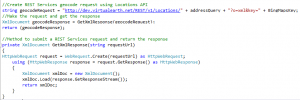
Once you have your key, you can test it out by making a call to their web service and retrieve the XML response with geographic coordinates. Here is a sample of what some of that code looks like:
This code can also be combined with other tools to search for points of interest near the intended location.
For more information on how this functionality can be set up, please refer to: https://msdn.microsoft.com/en-us/library/hh757509.aspx
If you are interested in geocoding within your CRM application, please reach out to Beringer, a Microsoft Gold Certified Partner.
Recent Posts


How can we help?
Whether you're seeking a fully managed IT solution or expert assistance with a Microsoft solution, we're here to provide expert advice whenever you need it.
Call us at (800) 796-4854 or complete the form below and we'll help in any way we can.